Heading out the door? Read this article on the new Outside+ app available now on iOS devices for members! Download the app.
Hiking Japan’s Iconic Volcano
I was 14 when my family and I took a trip to Japan—my first time out of the country. In addition to my daily ice-cold bottle of fizzy C.C. Lemon, a popular Japanese drink, the highlight of this two-week trip was our hike up Mt. Fuji. This large composite volcano is a rare wonder. First, because it is made of basalt, an unusual volcanic byproduct in Japan, as other large volcanoes produce andesite, and second, it’s a composite or cone-shaped volcano, which means it has layers and layers of hardened lava, lapilli, and ash from repeated eruptions.
As the highest and most prominent peak in Japan, Fuji is one of three holy mountains in the country and one of the most photographed mountains in the world. The year after my hike, UNESCO added Mt. Fuji to the World Heritage List as a cultural site because it “has long been the object of pilgrimages and inspired artists and poets.”
It’s been over a decade, but I still have my boots from this hike. I don’t wear them anymore as I’ve hiked thousands of miles since then. They’re a keepsake to me even though the toes are gnarled up from the uneven lava rock and gravel found above treeline. My shoes weren’t the only thing that changed during that trip. I did too. Hiking Mt. Fuji solidified my passion for steeps and peaks, something I carry with me to this day.
The Hike Up Mt. Fuji
Hiking season on Fuji isn’t very long—early July to early September. It’s the only time hikers don’t have to fight snow and ice on the sometimes-scrambly trail. It was August when my family and I did the Mt. Fuji hike.
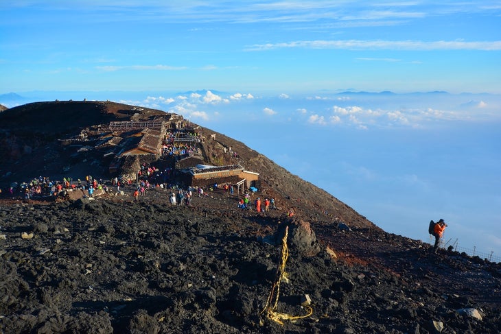
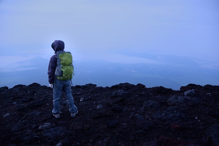
We took a highway bus to the Fuji Subaru Line Fifth Station, the start of the Yoshida Trail. Alongside hundreds of other tourists, we began our ascent around 10 a.m. and hiked until about 5 p.m. when we stopped at a hut for an overnight. We woke up around 2 a.m. to hike the rest of the way to the 12,388-foot summit for goraiko, the Japanese word for a mountaintop sunrise.
The Trails on Mt. Fuji
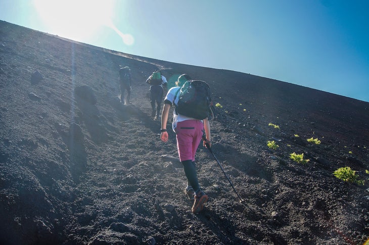
Wilderness this is not. Mt. Fuji is the most climbed mountain in the world, attracting hundreds of thousands of hikers each season. Like many mountains in Japan, Mt. Fuji is divided into stations. The first is the base and the tenth is the summit. Although you can start from the bottom, most hikers start at the fifth station of whichever trail they are hiking. Mt. Fuji has four major trails to the summit, each with its own trailhead and colored signs.
Yoshida Trail
Distance: 9 miles
Elevation gain: 4,881 feet
This is the most popular and crowded trail on the mountain. More than half of Mt. Fuji’s hikers each year use this trail—that means 149,969 hikers hiked it in 2019. Follow the yellow signs for this trail.
Trailhead: The Fuji Subaru Line Fifth Station is extremely plush, sitting at 7,550 feet elevation, a little less than two-thirds up the volcano. There are restaurants and gift and gear shops to purchase essentials before or after your trek. These shops, which also exist at other trailheads, are the last place to get just-in-case gear at a reasonable price before costs skyrocket higher up the mountain.
Terrain: The ascent begins with switchbacks along a relatively flat surface. Once you reach the seventh station, you’ll encounter more sizable lava rocks on and off the trail. From the eighth station to the summit, the Yoshida Trail merges with the Subashiri Trail.
The descent follows a different trail back down the mountain. Watch your footing on the downhill as it can be steep and unstable with loose rocks, especially if it’s raining. When it’s dry, it gets dusty and some hikers recommend packing gaiters to keep the grit out of your socks and boots.
Sleep: There are plenty of mountain huts with sleeping options. The huts all have bathrooms and snacks for sale. There are no huts on the descent until you reach the trailhead.
Subashiri Trail
Distance: 7.8 miles
Elevation gain: 5,744 feet
This trail isn’t as popular as the famous Yoshida and sees far fewer hikers, though it absorbs Yoshida’s crowds when the two merge at the eighth station. Follow the red signs for this trail.
Trailhead: At 6,560 feet, this trail’s fifth station starting point is a little over halfway up the mountain. This station is not as developed as others on the mountain, offering only a parking lot, bathroom, and two small shops and restaurants. There aren’t any coin lockers available, either.
Terrain: The hike starts below the treeline and takes you through a forest until you reach the seventh station. It eventually joins the Yoshida Trail and requires hikers to scale large lava rocks. The descent is similar to Yoshida Trail’s—steep and slidey.
Sleep: You won’t find any mountain huts on the descent below the eighth station. You can still access those along the ascending trail.
Gotemba Trail
Distance: 13.1 miles
Elevation gain: 7,769 feet
In 2019, only 12,230 hikers followed the green signs up the Gotemba Trail, the longest and least popular trail of the four trails.
Trailhead: Take the bus from Gotemba Station to the trailhead, which sits at 4,750 feet, about 40 percent of the way to the summit. This is the least-developed trailhead on Fuji and offers hikers a small shop, bus stop, toilets, and a couple of parking spots.
Terrain: Because Gotemba’s fifth station trailhead is the lowest in elevation, the hike to the summit is the longest. You’ll move through long, exposed slopes of volcanic gravel and fields of lava rock until the eighth station. Enjoy the pockets of foliage and ambient insect sounds as you hike. Known as the osunabashiri (“great sand run”), the descent trail is a quick route to the trailhead and you can run or slide down some of it. The wide, straight path is covered in lava gravel, so you can extend your stride without worrying about tripping on a rogue root. Some call it monotonous; some call it efficient. You decide.
Sleep: There aren’t many places to get shut-eye on this trail. There are only a few scattered mountain huts and none between Oishi-Chaya (near the fifth station) and the seventh station.
Fujinomiya Trail
Distance: 4.7 miles
Elevation gain: 4,324 feet
This is the second most popular route to the summit, offering a quick burn and easy accessibility.
Trailhead: The Fujinomiya fifth station is the second most developed of the four major trailheads going to the top of Fuji. It offers plenty of parking, a shop to get last-minute gear or souvenirs, a restaurant, and bathrooms. At 7,870 feet, this is the highest trailhead, making the hike to the summit the shortest.
Terrain: Generally, the Fujinomiya Trail is very rocky and steep. It’s the only out-and-back route, meaning the ascent trail is the same as the descent, which can make it congested during hiking season. There were 53,232 hikers on this trail in 2019. Note that this west-facing trail does not offer sunrise views before reaching the summit.
Sleep: There are about half a dozen mountain huts along the trail, one at every station leading to the summit. So, plenty of places to stay on the way up and down.
Directions and Logistics
There are lots of ways to get to the trailheads. Check for seasonality before booking—some routes and methods are only open during hiking season.
Yoshida Trail
From Fujikawaguchiko
Located in the foothills of Mt. Fuji, the Kawaguchiko Station is a fast, inexpensive way to get to the Yoshida Trail’s Fuji-Subaru Line Fifth Station. A one-way trip takes 50 minutes and costs 1,780 yen ($12.75) or 2,800 yen round-trip ($20). During hiking season, there are hourly bus trips each way, and in the off-season, there are four buses daily. There are no seat reservations.
From Tokyo
Start at Shinjuku Station’s bus and taxi terminal (Busta Shinjuku) and take the bus directly to Fuji Subaru Line Fifth Station. There are two trips daily to and from the fifth station during the off-season and hourly buses in-season. A one-way trip takes about 2.5 hours and costs 3,800 yen ($27.20). Seat reservations are required.
Subashiri and Gotemba Trails
These trail’s fifth stations are the easiest to access from Tokyo’s public transportation.
From Tokyo
Take the Japan Rail for the entire 2-hour journey from Tokyo to Gotemba. The JR Tokaido Line from Tokyo to Kozu is a 75-minute journey with plenty of daily departure times. From Kozu, change to the JR Gotemba Line to Gotemba Station, another 50-minute journey with one or two daily departures. The trip from Tokyo to Gotemba Station costs 1,980 yen ($14.20).
The Gotemba bus station offers rides to the Gotemba fifth station and Subashiri fifth station trailheads.
Busses run multiple times daily during the in-season from July to September. If you are outside that window, hire a taxi or drive your own car up the mountain. When they do run, the bus ride to the Subashiri Trail lasts an hour and costs 1,570 yen ($11.25) one-way and 2,100 yen round-trip ($15.05). The one-way bus ride to the Gotemba Trail is 40 minutes and costs 1,130 yen ($8.10) and 1,570 yen ($11.25) round-trip. Both fares are likely to rise.
Fujinomiya Trail
This trail’s fifth station is the most accessible via public transportation from western Japan. Take the Japan Rail Tokaido Shinkansen to the Shin-Fuji or Mishima stations where a bus will take you the rest of the way.
To Shin-Fuji Station
The direct one-way trip to the Fujinomiya fifth station is 2.5 hours long and costs 2,740 yen ($19.60) and 3,700 yen ($26.50) round-trip.
By bus from Mishima Station
The direct one-way trip takes two hours and costs 2,500 yen ($17.90) and 3,400 yen ($24.35) round-trip. This bus only runs during hiking season, July to September.
Places to Stay on Mt. Fuji
Want a chance to watch the sunrise from the top of Japan’s most famous peak? You’ll need a place to spend the night. There are huts along each of the four trails, which can hold between 70 and 350 hikers. You’ll also be well-fed in these huts. You’ll get bento box meals for dinner—usually a small amount of curry rice—and for breakfast you’re given rice, meat, and pickled vegetables meant to be eaten on the go. It’s important to note, the huts only accept cash for snack and drink purchases.
The average price to stay in one of the huts is between 5,500 yen and 8,000 yen ($40 to $57) per hiker per night. Some of the huts don’t accept hikers who arrive late at night. Plan accordingly when booking your accommodations and creating your trip itinerary.
In addition to the huts, you’ll find both public and hut toilets along the trails. All the toilets are ecological and use oyster shells, sawdust, and more to collect human waste. There’s a small fee to use the facilities, so bring some coins for that too.
Tips for Hiking Mt. Fuji
- The weather can change quickly. One hour, you’ll be hiking in the sunshine and the next, you’ll be in the rain. Gear that will keep you warm and dry in wind and rain is essential. June, July, and August are rainy months for Japan, so pack accordingly. Don’t be fooled by the humid, hot temperatures you feel at sea level—at the summit, temperatures are often just above freezing.
- The summit is 12,388 feet, putting some hikers at risk for altitude sickness. If you start feeling symptoms, you can purchase cans of oxygen at the mountain huts at different stations.
From 2023